
Most people chasing autumn colour head straight for the Yarra Valley’s vineyards or the beech forests of Marysville. Only a few who know better take the roads less travelled and explore towns lost in time. Come let’s explore Powelltown.
Route Guide Option
From Melbourne: Start from Melbourne (7 am) – (45 min) Lilydale – Yarra Junction (Coffee stop) – Gladysdale (Scenic detour) – Powelltown (Hub village) – Big Creek Rd (Forest tracks) – (Optional) Ada Tree – Warburton
From Pakenham/Officer: Drive Time: 1 hr 10/20 min – This is arguably the most beautiful option. Pakenham – Gembrook – Lanching Place – Yarra Junction – Powelltown
Leave Melbourne early and I mean before 7 am for a comfortable day trip. Warburton Highway east of Lilydale begins to reveal itself around Seville, where roadside orchards still holds fog in the mornings and the Yarra River flashes occasionally below you. Morning mist lingers in the creek gullies until 9 or 10am. This is agricultural country giving way to something wilder.
Take a coffee break at Yarra Junction and visit the Upper Yarra Museum. Its a small town that hasn’t changed much.
Most drivers follow the Warburton–Noojee Road directly toward Powelltown but we prefer a better one that takes you through the hamlet of Gembrook – Yarra Junction – Gladysdale via Three Bridges and Gilderoy.
Powelltown (via a 15 min detour through Gladysdale – Gilderoy)
This approach to Powelltown follows the ghost of the old horse-drawn tramway that predated the narrow-gauge railway. This was a route used by paling splitters moving timber to Yarra Junction before the great mills arrived.
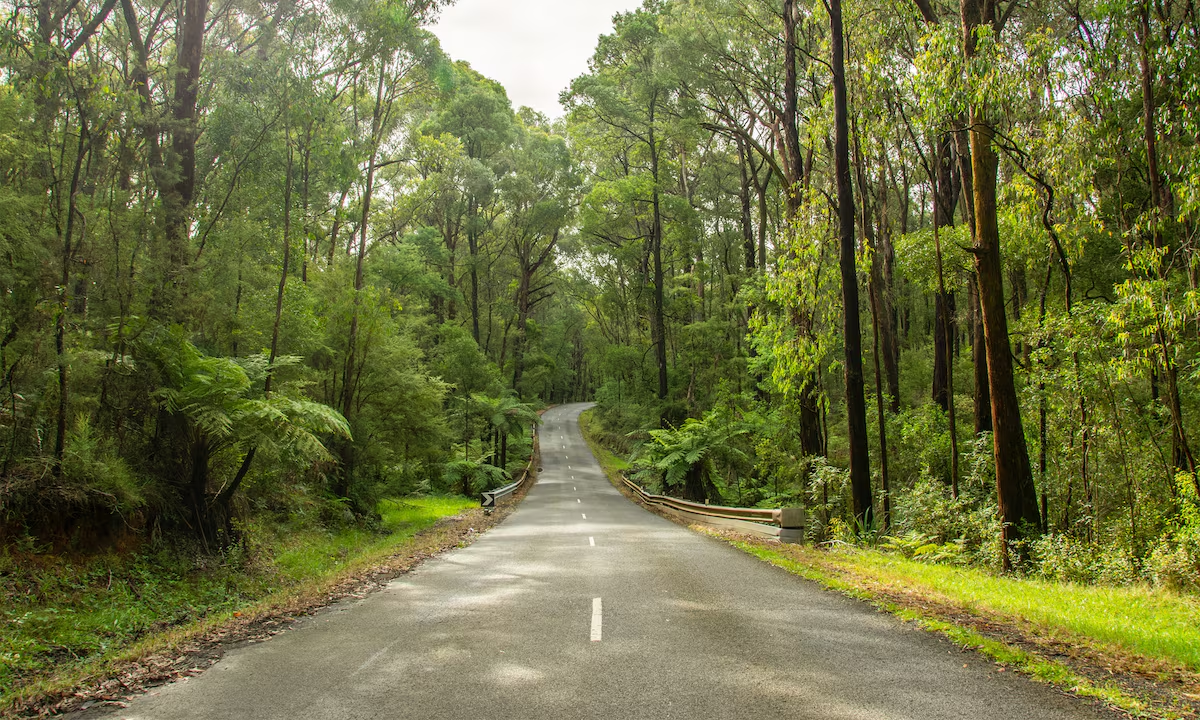
The road takes you over rolling hills and through patches of remnant bush and some apple orchards. Pull over at the first sharp rise east of Three Bridges. On a clear autumn morning the view across the Little Yarra Valley to the forested ridgelines beyond is exceptional, and often completely deserted.
Local Legend of Powelltown
Powelltown takes its curious name not from a person but from a failed idea.
In 1911, the Victorian Powell Wood Process Company was formed to exploit a new method of wood preservation using molasses and chemicals, supposedly rendering mountain ash harder, stronger, and rot-resistant. Flush with gold-rush investors’ money, they built a narrow-gauge railway, a processing plant, and essentially an entire town in the forest. However, due to the unsuccessful preservation method, it was abandoned within a few years.
Learn More
The company restructured, reverted to untreated timber, and the settlement now named ‘Powelltown’ carried on without the process that gave it its name. For decades it was one of Australia’s most productive sawmilling centres. Then Black Friday came.
The devastating fires of January 1939 or what we refer to a ‘Black Friday’ tore through these forests and changed everything. Mills were destroyed, tramlines melted, and entire settlements disappeared overnight. The fires of 1926 and 1932 had been bad but Black Friday was catastrophic. What remained was rebuilt, but the era of the great bush mills was effectively over. Road haulage replaced the tramway, and by 1944 the famous narrow-gauge passenger railway had closed forever.
Today, Powelltown is tiny with a handful of houses, a sawmill that still operates, a heritage church and a picnic area. But the town a network of walking trails that go across the old tramlines and have become some of Victoria’s most atmospheric forest walks.
The town itself is worth a slow stroll. You can visit the Powelltown Union Church on the main street. Built in 1927 from mill timber by volunteer labour, this is believed to be one of the last remaining Union Churches in Victoria.
After exploring the remnants of the timber era and wandering the historic trails, take some time to visit the ‘Powelly Pub’ which is Powelltown’s beloved local watering hole and an essential stop on this autumn drive. Try and spot the family of Kookaburra who live on one of those tall trees located right behind the pub!
Drive through forest roads
The sealed road ends just past the Powelltown town. From here, a real road adventure begins leading into the Yarra State Forest.
Big Creek Road ( 6 km east of Powelltown)
Big Creek Road climbs steadily from the valley floor into mountain ash country. In autumn, the canopy along the creek gullies below the road turns a warm gold-amber as the myrtle beech trees colour. The road is generally well-formed but narrows considerably in places, and creek crossings after rain can be slippery.
Keep your eye out for the “Ada Tree” signpost as this is your turn for the most significant detour of the drive.
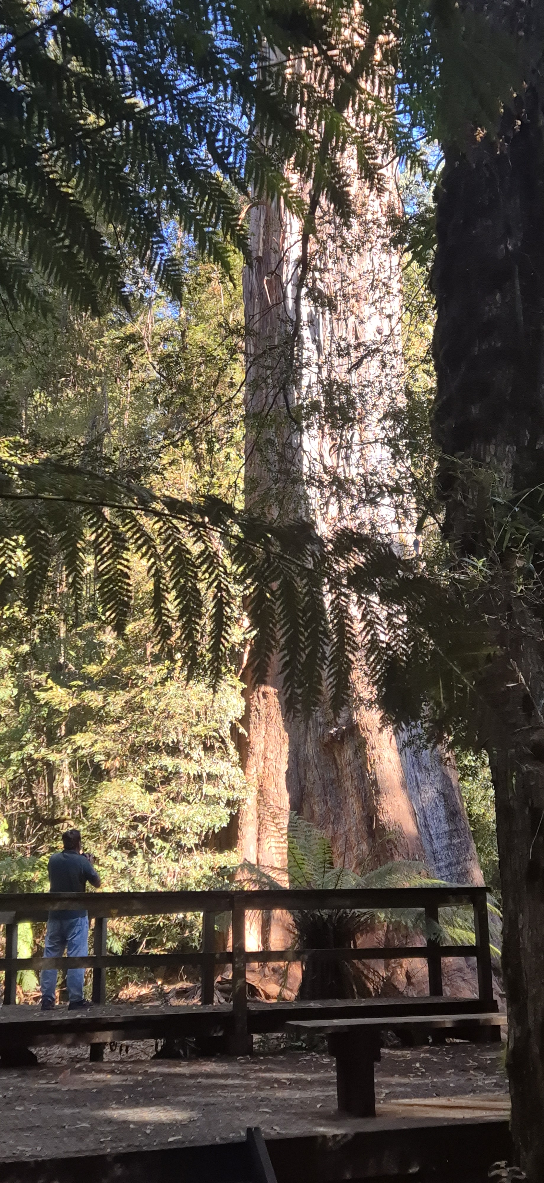
“Standing beneath the Ada Tree, surrounded by silence and filtered light, it is hard not to feel a sense of reverence. This tree has withstood storms, fires and a century of logging a living reminder of the ancient forest that once blanketed this landscape.”
Roughly 2 km along Big Creek Road, pause at the roadside parking area near the old Bump Tunnel. The tunnel itself is a 313 metres of timber-lined bore blasted through a ridgeline in 1925-26 to allow the tramway an even grade. The entrances were demolished after World War II but the portal approaches are still visible in the undergrowth, moss-covered. This place has a different atmospheric energy.
Starlings Gap
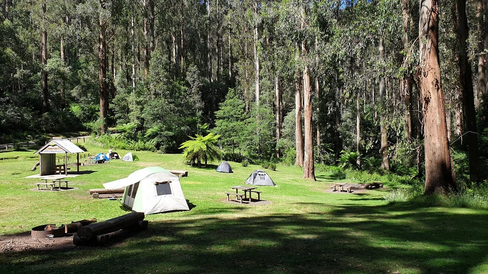
Perched at 740 metres above sea level, the open, grassy clearing at Starlings Gap sits surrounded by tall mountain ash and sits stone’s throw from cool temperate rainforest. It’s the high point of this drive and on a clear autumn day the quality of the air and light up here is noticeably different. Even if you don’t plan to camp, Starlings Gap is worth the drive for the atmosphere alone. The site has picnic tables, firepits and toilets, and the surrounding forest is spectacular in autumn. From here, the short drive to Seven Acre Rock (a short walk of around 600m one way and 45 minutes return.) offers a granite outcrop with sweeping views across the forested ridges.
This campground functions as the overnight hub for the Walk Into History multi-day hike. The Walk Into History route connects old bush mill sites like Ada No. 2, the New Federal Mill, and several smaller operations where boilers, winches, and machinery lie slowly dissolving back into the forest floor.
For more details and insights on this trail you may visit https://www.trailhiking.com.au/hikes/walk-into-history.
The network of old timber tramways converted into walking tracks around Powelltown is unlike anything else in Victoria. More on the Powelltown tramways can be read at https://en.wikipedia.org/wiki/Powelltown_tramway
| Walk | Distance | Time | Notes | Grade |
| Ada Tree Walk | 3.2 km return | 90 min | Easy rainforest meander to the great tree. Best walk for beginners. Dogs welcome. | Easy |
| Reid’s Tramline Walk | 6 km loop | 2–2.5 hrs | Disused tramline trail starting near Powelltown. Gentle grades, deep forest atmosphere. Peak autumn leaf cover. | Easy |
| Big Pats Creek to Starlings Gap | 10 km one way | 3–4 hrs | Climbs through wet sclerophyll forest to the ridge. Arrange a car shuttle or return the same way. | Moderate |
| Mount Beenak Loop | 12 km loop | 4–5 hrs | Summit views reward a tough climb via Fifth Dam Track. Anticlockwise recommended to descend the steep section. | Hard |
| Starling Gap to Ada Tree Circuit | 25 km circuit | 6–7 hrs | The full experience: tramway relics, mill sites, Ada Tree, creek crossings. Bring navigation. Best as overnight from Starlings Gap camp. | Hard |
| Walk Into History | 33 km point-to-point | 2 days | Warburton to Powelltown (or reverse). Victoria’s finest forest history walk. Tramways, mill ruins, old-growth forest. | Multi-day |
For bikers https://www.ridetimebikes.com.au/gravel-rides has plenty of loops to choose from.
Notes:
- Avoid total fire ban days in autumn for obvious reasons. The forest roads may also be closed and campfires prohibited. Always check the Vic Emergency app and Forest Fire Management Victoria conditions before you leave.
- Forest roads are narrow, winding, and shared with logging trucks. Treat them as a two-way road where the other vehicle may be very large and moving fast. Drive with full headlights on at all times. Pull completely off the road if you see a truck approaching.
- Mobile coverage is limited or absent from Powelltown onwards. Download offline maps (Maps.me or Gaia GPS with the relevant VICMAP layer) before you leave. Let someone know your planned route and expected return time.
- After heavy rain, creek crossings and steep gravel sections can become challenging. If in doubt, turn back as conditions can change quickly. A standard AWD or high-clearance 4WD is recommended for Big Creek Road and Ada River Road in wet conditions.
The Yarra State Forest sits on Country belonging to the Gunai Kurnai people, who have cared for these forests for tens of thousands of years. Travel gently, leave no trace, and take rubbish with you when you leave.
Location & distance guide to Powelltown
Other scenic route options
- Drive time: 1 hr 10/20 min – This is arguably the most beautiful option.
Pakenham – Gembrook – Lanching Place – Yarra Junction – Powelltown
or
Drouin – Neerim South – Noojee – Powelltown - Drive time: 1 hr 45 min
Berwick – Beaconsfield – Emerald – Launching Place – Warburton – continue along the C425 toward Powelltown - Drive time: 1 hr 30 min – The section between Gembrook and Powelltown is scenic and lightly trafficked, passing through tall forest and rural clearings.
Berwick – Officer – Pakenham – Nar Nar Goon – Tynong North – Gembrook – Powelltown - Drive Time: 1 hr 20 min – More open farmland early on, then forest closer to Yarra Junction.
Drouin – Longwarry – Labertouche – Yarra Junction – Powelltown
