When people speak of autumn in Victoria, they usually travel towards Macedon Ranges or Bright. But raely does a traveller choose to explore the Strathbogie Ranges that are just as magnificient.
A granite plateau rising from the pastoral plains between Euroa and Mansfield, laced with winding backroads, small creek valleys full of peppermint gum and yellow box, and an increasing density of small vineyards: this is high country before it was packaged. The roads feel genuinely remote. The skies are enormous. In autumn the colour comes to the gum woodland understory, not the European trees which are a different register entirely, subtler but deeper, and in the right light, extraordinary.
Important: January 2026 Longwood Bushfire
In January 2026, catastrophic bushfires originating near Longwood tore through approximately 136,000 hectares of the Strathbogie Ranges, causing devastating losses to farms, vineyards and homes. Fowles Wine (Avenel) lost all 300 acres of vines and the family home, though their cellar door and restaurant survived and reopened. Elgo Estate also lost their vineyard. Multiple properties across the Upton Hill and Longwood area were affected. Some sections of the ranges landscape described in this guide will look different after the fire.
Before visiting, check current road conditions, individual cellar door and attraction status, and consider that your visit and purchase of local wine is one of the most meaningful ways to support this community’s recovery.
Route Guide: 150 km from Melbourne
Melbourne – Hume Fwy – Avenel (Fowles cellar door) – Euroa (Heritage town) – Strathbogie Rd (Into the ranges) – Gooram Falls (Seven Creeks) – Boho (Honeysuckle Creek) – Boho South (Forest & granite) – Mansfield
What Makes the Strathbogies Different
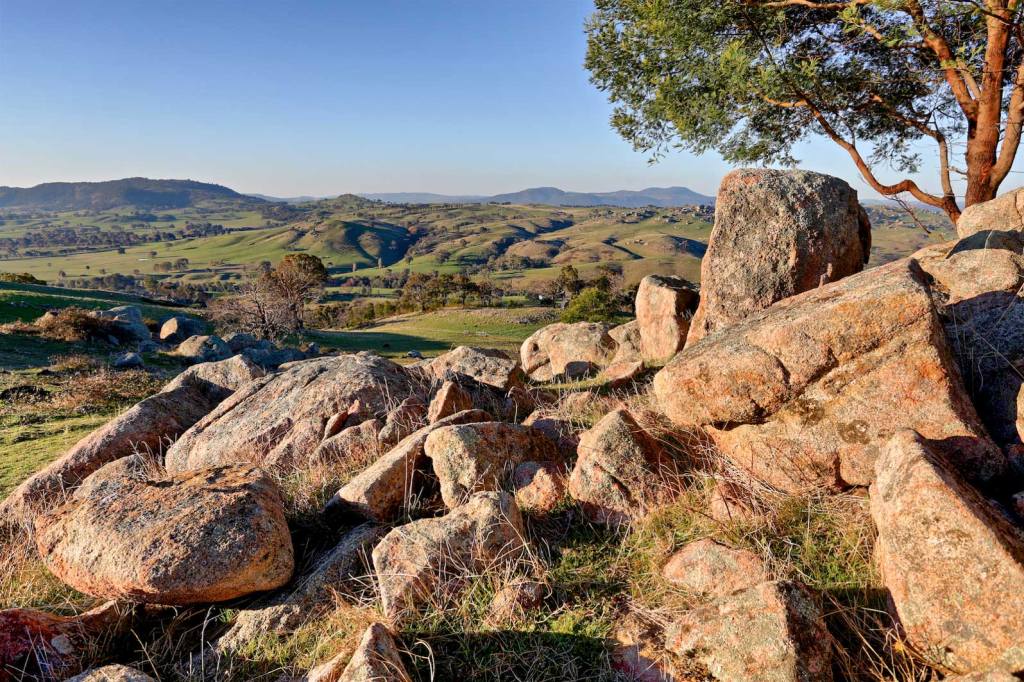
The Strathbogie Ranges are a granite intrusion not a folded mountain range like the Victorian Alps, but a dome of ancient rock that was pushed up through the surrounding sediments 370 million years ago and has been exposed by erosion ever since. The result is a landscape of rounded hills, open grassy woodlands on the plateau, and dramatic tors and boulder outcrops at the higher points. The granite decomposes into a deep, coarse sandy soil that holds moisture poorly but provides excellent drainage that is ideal for cool-climate viticulture, which is why vineyards began appearing here from 1975 onward.
At 500–700 metres elevation, the ranges create their own microclimate: cooler and wetter than the plains below, with long cold winters, moderate summers, and an autumn that arrives noticeably earlier than the surrounding lowlands. The temperature differential between the plateau and Euroa in the valley below can be as much as six degrees on a still autumn morning — you feel the change in the air the moment the road begins to climb.
Local Legend: Ned Kelly’s boyhood home and the bank robbery that made Euroa famous
Avenel, at the Hume Freeway exit for this drive, was the childhood home of Ned Kelly. The family lived in the area in the 1860s when Ned was a boy, and the Avenel stone bridge — six arches, built in 1859 is one of the oldest surviving structures associated with the Kelly story.
The connection intensifies at Euroa: on 10 December 1878, Kelly and his gang (including brother Dan and Steve Hart) rode into town and robbed the National Bank, escaping with £2,060 which was equal to the bank’s entire fortnightly profit. The gang took the bank manager, two tellers, the manager’s mother, wife, seven children and two servants hostage, transporting them to Faithful Creek station while they looted the safe. The building that housed the bank was demolished in 1975, but the 1884–85 replacement National Bank building still stands on Binney Street and is among the finest examples of the “polychromatic” Victorian banking architecture in regional Victoria. The Farmers Arms Hotel Museum on Kirkland Avenue holds the most comprehensive Kelly collection in the Euroa district.
Exit the Hume Freeway at Avenel and pause here before the ranges. The Royal Mail Hotel, dating from the 1850s, is on the main street, a classic Cobb & Co staging post building that once served the coaches on the Sydney–Melbourne run. The six-arch stone bridge over the Hughes Creek (built 1859) is a short walk from the main street and is a fine piece of colonial engineering. Fowles Wine is 2 km from the Hume Freeway on Lambing Gully Road and is the logical first stop: their cellar door and restaurant survived the January 2026 fires and are open. Visit and buy wine directly as this is one of the most effective ways to support a producer rebuilding after devastating losses.
Euroa, the river town at the range’s foot
The name Euroa is thought to derive from ‘Yera-o’ and means joyful, or the meeting of waters. A name apt for a place alive long before the gold rush or the Kelly gang or the vineyards arrived.
Euroa’s name is thought to derive from ‘Yera-o’, an Aboriginal word meaning ‘joyful’ — and before European settlement, the Ngurelban people of this country had reason to name the confluence of Seven Creeks’ headwaters this way. The town was established at the crossing of Seven Creeks in 1854, grew rapidly as a supply stop on the Sydney–Melbourne road, and accelerated again when the railway arrived in 1873. Its heritage streetscape on Binney and Railway Streets is well-preserved: the 1877 Romanesque courthouse (a rare design in Victorian regional courthouses), the 1890 post office, the butter factory building of 1901, and the Seven Creeks Hotel at the corner of Tarcombe and Foy Streets — a building that began as a tent store in 1853 and still has the original bar from the 1860s brick hotel.
Seven Creeks Park & Heritage Walk
Seven Creeks runs through the heart of Euroa, shaded by a continuous corridor of native trees — remnant floodplain woodland that has been preserved as parkland. The Seven Creeks walking tracks extend 7 km from the picnic area on Kirkland Avenue, through the floodplain woodland and back via the town’s heritage streetscape. The shorter 3 km loop is adequate for a morning stop. There is a weir on Seven Creeks that has formed a swimming lake, popular in summer and reflective in autumn.
The Balmattum Hill walking track, 2.3 km return from the car park north of town, climbs to a Federation-era rotunda with a bird’s-eye view across Euroa and the surrounding plain, with the Strathbogie Ranges rising steeply to the south and east.
Euroa Arboretum
A 27-hectare native garden established to preserve and display plant species indigenous to north-east Victoria. In autumn, the arboretum transitions between its summer and winter characters — some canopy colour, the dry grass of the surrounding paddocks, the sound of the creek that runs through the lower section. A trout dam allows fishing. The sculpture walk connects the key points. It is genuinely quiet here, even on weekends — this is not a well-publicised attraction and most visitors to Euroa never stop here.
The Strathbogie Loop Road: Climbing Into the Granite
From Euroa, take Templeton Street south-east under the Hume Freeway — a cavernous overpass — and follow the Strathbogie Road as it climbs steadily into the ranges. The paved road follows Seven Creeks upstream from the township, and the landscape changes visibly within five kilometres: the flat flood plain gives way to rolling hills, then to steeper terrain as the granite appears in the roadside cuttings and in the exposed boulders on the hillsides. The patchwork quality the brief describes is very real from this road: wool paddocks, remnant box-ironbark woodland, vineyard rows on the better-drained northern slopes, and occasional granite outcrops rising from the grass like oversized furniture.
Stop: Polly McQuinns — the Dam in the Ranges
Near the township of Strathbogie Village, a dammed section of Seven Creeks has created a still-water swimming and picnic spot tucked among granite boulders. Called Polly McQuinns, it is a local landmark — calm water over a weir falling onto large rounded granite boulders, surrounded by box woodland that turns warm gold in autumn. In summer it draws swimmers; in autumn it’s often empty and extraordinarily picturesque. The nearby Strathbogie Village has a small general store café and a Bridge to Bridge Walk along Seven Creeks and Spring Creek that covers 2.5km through shaded creek-line country.
Stop: Gooram Falls — Seven Creeks Gorge Country
The most dramatic waterfall on the Seven Creeks system, Gooram Falls are accessible via a 400-metre walking track from the car park off the loop road. The falls are part of a section of Seven Creeks that drops precipitously from the ranges through rapids, cascades and gorge country. The reserve protects creek-line grassy woodland — good birdlife habitat. In autumn the falls are often at a good flow from the first seasonal rains, and the gorge walls are coloured with lichen and moss. A second access point 2km further reaches a larger cascade. Both tracks can become boggy after rain.
Boho & Boho South
Boho: The Honeysuckle Creek Valley
Boho is one of those Victorian place names that barely registers on most maps but carries a quality of atmosphere all its own. The hamlet sits in the Honeysuckle Creek valley on the western slopes of the Strathbogie Ranges — a cool, sheltered drainage that runs north to join the Broken River system. The road through Boho and south into the state forest crosses and recrosses the creek on small timber bridges, passing through open peppermint gum woodland where wallabies are often grazing at the roadside in the early morning and at dusk.
The Old Weir Walk, Boho: 2.2 km gentle loop · Honeysuckle Creek valley
An easy loop through the Honeysuckle Creek valley woodlands to a historic old weir — an unexpected piece of colonial water infrastructure hidden in the foothills. The walk passes through open box woodland and along the creek corridor, with the sound of water present throughout. The description of this walk as revealing “a special place secreted away in the foothills” is accurate — the weir and its small impoundment sit in a quiet bend of the creek where the tree canopy arches overhead, and the autumn woodland around it has a particular quality of sheltered stillness.
Honeysuckle Headwaters Walk, Boho South: 7 km loop · Strathbogie State Forest · Moderate
A longer loop through open and pretty peppermint gum and yellow and long-leafed box grassy woodland in the state forest above Boho. In the wetter gully areas, blue gums appear, and seasonal wildflowers add colour in the understory. Due to past logging, the trees here are relatively young — but remnant older large trees with active wildlife hollows can still be found, and the birdlife is excellent. In autumn, the dry grass of the grassy woodland between the trees takes on a particular warm gold colour in late afternoon light that is one of the signature tones of the Strathbogie landscape. Note: the state forest was affected by the January 2026 fires in some sections — check Parks Victoria closures before driving or walking in the state forest.
Wine Country: The Strathbogie Cellar Doors
The Strathbogie Ranges received official wine region recognition in 2001, though the first plantings — by the Plunkett family at Mount Helen — began in 1975. The region now has approximately 1,500 hectares of vineyard and over 25 cellar doors. The cool climate at 430–550 metres elevation suits riesling, chardonnay, pinot noir and shiraz particularly well, and the best producers here make wines of genuine elegance and complexity.
Following the January 2026 fires, visiting and buying directly from the surviving cellar doors is one of the most direct ways to support recovery.
Fowles Wine, Avenel
– Cellar door & restaurant open 9am–5pm daily
The flagship producer of the Strathbogie Ranges — five-star James Halliday, multiple times Victoria’s Best Tourism Winery, and the cellar door that made this region legible to Melbourne day-trippers. The cellar door and restaurant survived the January 2026 fires and reopened within days, while all 300 acres of vines were lost. Visit. Buy. Come back. The “Ladies who Shoot their Lunch” shiraz is the signature; the riesling and chardonnay are exceptional. Farm-to-table menu in the restaurant, views of Mount Bernard, courtyard seating.
Maygars Hill Winery, Longwood
– Cabernet & shiraz
A 20-acre property hand-planted in 1997 by Jenny Houghton. Six acres of cabernet sauvignon and shiraz on light sandy loam, right on the border between the Strathbogie Ranges and Goulburn Valley wine regions. Small, personal, and producing wine of real quality. Named after Lieutenant Colonel John Maygar VC, a local Boer War hero — one of the three Victoria Cross recipients from the Euroa district.
Strathbogie Estate, Strathbogie village
– Boutique family operated
Launched in 2018 by owners Bruno and Karin, who set out to create a cellar door experience as much about place as wine. Located near the township of Strathbogie, it is the most immersively located cellar door on the plateau — the granite hills and open woodland surrounding the property give it a character distinctly different from the flatter cellar doors at the range’s foot. Call ahead to check hours before visiting.
Garners Heritage Wines, Longwood East
– Boutique shiraz
A 1.8-hectare boutique vineyard on the Longwood-Mansfield Road producing a shiraz described as exceptional. The warm summer temperatures at Longwood East — lower elevation than the central plateau — produce full-bodied red wines of real character. Small operation, call ahead. One of the newest in the region but already producing wine that has attracted attention beyond the district.
Walking Trails of the Strathbogie Ranges
| Walk | Distance | Time | Notes | Grade |
|---|---|---|---|---|
| Seven Creeks Walk, Euroa | 3–7km options | 1–2 hrs | Peri-urban bushwalk along the Seven Creeks floodplain woodlands. Flat, well-signed. Multiple access points. Good birdlife and remnant native vegetation. | Easy |
| Balmattum Hill Walk | 2.3km return | 60–75 min | Climbs to a rotunda with panoramic views over Euroa and the surrounding plains and ranges. Steep in sections. Worth the effort for the orientation and photography. | Moderate |
| Gooram Falls Track | 1.8km short / 2.5km extended | 45–75 min | Gorge-line walk to the most accessible waterfalls on Seven Creeks. Beautiful creek-line grassy woodland. Can become boggy in wet weather. Best after the first autumn rains. | Easy |
| Bridge to Bridge Walk, Strathbogie Village | 2.5km one way | 45–60 min | Follows Seven Creeks and Spring Creek through shaded gully woodland. Gentle, flat, good birdlife. Café at the village for start or end. Point-to-point — arrange return transport or walk back. | Easy |
| Old Weir Walk, Boho | 2.2km loop | 45–60 min | Gentle loop through Honeysuckle Creek valley woodland to a hidden colonial weir. Quiet, sheltered, atmospheric. One of the least-known walks in the Strathbogie Shire. | Easy |
| Honeysuckle Headwaters, Boho South | 7km loop | 2.5–3 hrs | State forest loop through grassy woodland and wet gully. Good fungi in autumn and winter. Wildlife hollows and older trees. Check fire closure status before visiting following January 2026 fires. | Moderate |
| Rocky Ned Lookout, Creek Junction | 4km return | 1.5–2 hrs | Granite outcrop lookout with views across the Sugarloaf Creek valley to the high country. Modest elevation gain but sustained climbing. View described as impressive. Best on clear autumn mornings. | Moderate |
| Mount Wombat Lookout | 5.6km return | 2–2.5 hrs | Described as “the walk, the forest, the fauna, the flora, the fungi, the view, the joy” — one of the best-regarded walks in the ranges. Steep in sections. Summit views. Rich fungi from May onward. | Steep |
The Strathbogie autumn is different from the European-tree-dominated experiences of Bright or Mount Macedon. The colour here is native woodland colour — the yellow box turning pale gold, the peppermint gums losing their older leaves in orange drifts, the grass warming from green to amber. It is subtler than a maple forest but, in the right light — particularly that late-afternoon light on the open plateau with an enormous sky overhead — it is the more expansive and genuinely dramatic experience.
Following the January 2026 Longwood fire, some roads and areas of the Strathbogie State Forest may have changed conditions. Check VicEmergency and Parks Victoria for current closures before visiting.
Camper-trailers and caravans are not recommended on the narrow range roads. Mobile coverage is limited once you leave the Hume corridor — download offline maps before departing. Fuel up in Euroa or Avenel before entering the ranges; there is limited fuel on the plateau.
The Strathbogie Ranges lie on the traditional Country of the Taungurung and Yorta Yorta peoples.
The Strathbogie Ranges wine community has faced an extraordinary crisis in the January 2026 fires. Visiting, purchasing wine directly, and returning are among the most meaningful things a traveller can do for the region’s recovery.
