Everyone knows Daylesford but only few explore what lies west of it. Let’s explore Trentham, Lyonville and Glenlyon and travel up onto the Great Dividing Range.
The Calder Freeway to Woodend is a bland but efficient corridor and the landscape changes once you leave it. From Woodend, the C309 climbs steadily through the southern edge of the Macedon Ranges toward Trentham. The road passes through farmland that gives way to taller, denser bush as you gain altitude. The temperature drops measurably at the 700-metre mark and by 800 metres, where Trentham sits, autumn mornings are cold, frequently foggy, and often still. Exactly the kind of weather autumn demands.
An alternative and better approach for those who want the scenic version: leave the Calder at Malmsbury and take the Malmsbury–Trentham Road through the ranges. It is a winding, quieter road through open grazing country and remnant bush and you arrive at Trentham from the east.
The long-avenue approach on this road, lets you see old oak trees planted by early settlers and is one of the prettiest autumn scenes in Central Victoria. No crowds. No reason to rush.
Trentham
Local Legend about the ruined forest and the Trewhella Brothers & Betty’s Hill
Trentham exists because of timber. The dense Wombat Forest drew woodcutters from the mid-1850s, and by the 1880s there were 36 sawmills operating across the Wombat and Bullarook Forests, shipping timber to Melbourne and across Victoria to line gold mine shafts, support railway sleepers and build the colony.
Learn More
The railway arrived in 1880 and at its peak was carrying over 20,000 tonnes of freight a year, almost all of it timber. By the 1890s, Royal Commission found the forest so heavily logged it was declared “a ruined forest” and was closed to further logging for 50 years to regenerate. The forest you walk through today is that second growth.
The brothers Benjamin and William Trewhella, who came with the gold rush and stayed for the timber, built a foundry in Trentham in the 1890s and invented the Trewhella jack-and-stump grubber. It was once the indispensable tool of farm clearing across Australia. Their foundry became the town’s most enduring industry. Lurking in the local history is a darker footnote: Betty’s Hill, north of Trentham, is named after a small girl who was lost in the dense forest in the early days of settlement, her body found later and covered with stones where it lay. The cairn is still there.
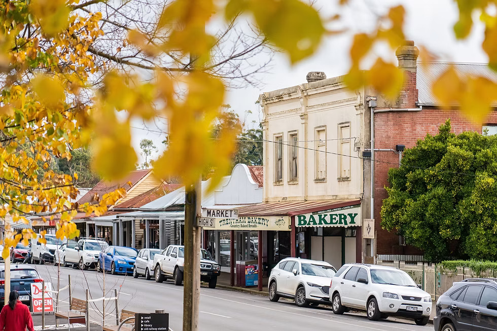
The town today is small with two short main streets, timber shopfronts with covered awnings, the old station at the end of Market Street, and the Cosmopolitan Hotel on the corner of High Street, which has been standing since 1866. What changed in the last decade is the food.
Trentham is a food destination
Trentham has quietly become one of the best small-town eating destinations in Victoria, with a density of genuinely good cafes, bakeries and restaurants that belies its population.
For a town of its size, Trentham has an absurd density of good food. This is partly the Daylesford effect as the surrounding region has become one of Victoria’s leading foodie destinations, and the produce culture has seeped westward. The key establishments in order of atmosphere:
- Redbeard Historic Bakery: Has a heritage wood-fired oven producing organic sourdough of genuine quality. The bakery has been described as a “charming emblem of the Macedon Ranges.” Please arrive early for the best loaves as they sell out faster.
- Trentham Bakery: The old-school option alongside Redbeard’s has homemade pies and sausage rolls that are consistently praised with freshly brewed coffee. This is the kind of bakery that has been feeding country towns since the gold rush era. Its affordable, honest, opens early.
- Trentham General: Housed in the beautifully restored old Bank of Australasia building, this café is brimming with architectural character. Good coffee and al fresco dining in a heritage setting.
- The Cosmopolitan Hotel: Standing since 1866, the Cosmo is one of Central Victoria’s most storied country pubs. The courtyard, shaded by century-old elm trees that are at their most spectacular in autumn gold, is the destination lunch spot.
- Du Fermier: Offer a surprise feast inspired by French country cooking using regional produce. The small but punchy menu changes with what’s available and reservations are essential.
Trentham – High Street in Autumn
Walk High Street early, before the weekend visitors arrive. The European trees planted by the Victorian-era settlers include elms, oaks and chestnuts turn amber and deep copper in April and May. The low morning light catches the colours perfectly and photographers specifically come here for that.
The old weatherboard storefronts, the period pub facades, the hand-lettered bakery sign are perfect for a stroll and makes you feel like you’re in a scene from the 1920s. The Trentham Police Complex on Camp Street, which served as the town’s police station from 1866 to 1987, is open occasionally and preserves five portable weatherboard buildings including a charge office, stable, and cells. Worth the look if you are into history and architecture like me.
Trentham Falls (2 kms from town)
Trentham Falls are the highest single-drop falls in Victoria. The Coliban River plunges 32 metres in a single sheer drop over a basalt column formation left by a lava flow approximately five million years ago.
The walk from the car park to the Northern Lookout takes only five minutes. But the entry becomes slippery during rains so be careful and avoid if it looks too bad to walk.
The reserve protects an example of pre-colonial vegetation that a botanist named George Augustus Robinson documented in 1840 as a “fully mature cool climate forest teeming with life.” Much of that forest was gone within two decades. The regrowth that surrounds the falls today is tall, atmospheric, and increasingly ancient-looking exactly the kind of native bush that turns a particular dark, saturated green in overcast autumn light. Expect to see manna gum, messmate and peppermint all over the area.
The Domino Trail: A Railway Reclaimed by the Forest
The Domino Line: Gold, Timber & Abandonment
The railway that connected Trentham to Lyonville opened in 1880 as part of the Carlsruhe–Daylesford branch line, built to service the timber industries of the Wombat Forest. For decades it was one of the busiest freight lines in Central Victoria with those 20,000+ annual tonnes mostly riding this track.
The Trentham station was one of the two largest consignors on the entire branch line. Lyonville’s station, at its peak in 1891, was handling 10,245 tonnes of outward goods per year which was the second largest total in the whole state. By the 1950s the timber was largely gone, better roads had replaced the rails, and the line was closed in 1978. The tracks were lifted. The sleepers were left. The forest grew over everything. What remains is the Domino Rail Trail with six kilometres of old railway alignment that the Wombat Forest is slowly, deliberately, beautifully absorbing. One recent writer described it as “hauntingly beautiful: a living museum.”
The Domino Trail: Trentham to Lyonville – 12 km return
The trail begins at the old Trentham Railway Station on Victoria Street which is now the tourist information centre. The rusted carriages still sit in the overgrown yard. Walk west out of the station precinct and the old sleepers are visible beneath your feet, the grass grown up through the ties. The trail crosses a main road and enters the forest proper, where the atmosphere changes immediately with taller trees, dimmer light, the sound of the forest replacing the sound of the town.
There is something hauntingly beautiful about a railway reclaimed by the forest — the rhythmic crunch of gravel under the tires, the skeletal, rusting remains of vintage train engines. The Domino Trail is more than a path through the forest; it is a living museum.
The path runs through stands of manna gum, peppermint and mountain gum whose canopy closes over the old alignment in autumn. Interpretive signage at certain points explains the logging history. One rest stop beside a cutting marks the difference in tree height between a section logged more recently and one that has been regenerating since the 1890s closure. The visual evidence of this contrast, once pointed out, is striking. Halfway along, the trail passes through a hill cutting where the ground rises steeply on both sides offers a small taste of the engineering effort of the original construction. Near the Lyonville end, the route diverts around a beautiful old wooden bridge that is no longer safe to cross, offering instead a low-angle view of the structure from below.
The trail ends at the old Lyonville railway station site, now the car park of the Radio Springs Hotel. The hotel has stopped serving meals in early 2025 due to kitchen staffing difficulties so check ahead before relying on it for lunch.
Lyonville
Lyonville is barely a hamlet named after James Lyon, who settled in the area in the 1860s, and it carries its history quietly. The logging that made this settlement briefly the second-busiest freight station in Victoria is now invisible. The forest has grown back, the sawmills are gone, and the whole place feels half-asleep in the best possible way.
Lyonville Mineral Spring
About 2.5 km before you reach Lyonville from Trentham, turn onto Lyonville Springs Road for 1.5 km to reach the mineral spring. The spring sits in a picnic area nestled between the Loddon River Road and the Loddon River itself, enclosed by a candlebark forest. There is a hand pump under a small rotunda shelter, a 1914 concrete trench built to capture the flow, and a bore sunk in 2007 that is 35 metres deep. The water is carbonated and cold and far more gaseous than the famous Daylesford springs. The surrounding candlebark forest in autumn is ethereal: pale grey-white trunks against the copper and amber of the understory, the sound of the river, almost no visitors on a weekday.
A note of historical atmosphere: when the 1914 spring trench was being built, workers were warned to take precautions against released carbon dioxide gas from the carbonated water. The trench still fills with water after heavy rain and needs to be pumped out. A small carved mesh guard installed over the trench opening remains. The spring has been a picnic destination since the early 1900s and was previously called ‘Picnic Area Spring’ which was a gentler name for a very old habit of gathering by this carbonated water in the forest.
Glenlyon
Glenlyon is 5 km from Lyonville and often missed out by travellers. It is a small rural village but one of Victoria’s best-kept scenic secrets especially in autumn. It’s a very scenic little drive with farmland views and colourful trees lining parts of the road.
Visit Glenlyon General Store for coffee and something warm from the kitchen. Sit outside if the sun’s out. Take a short bush walk around the Glenlyon Mineral Springs Reserve and bring a bottle if you’re curious to taste the local mineral water.
The Forest Roads: Driving the Wombat
Trentham–Lyonville Road (Daylesford Road) is a sealed 8 km drive perfect to enjoy an iconic autumn corridor.
The Wombat State Forest covers 70,000 hectares between Woodend and Daylesford, straddling the Great Dividing Range. It contains hundreds of kilometres of forest roads — from sealed through-roads to rough tracks suitable only for high-clearance vehicles. For the autumn drive, several routes stand out for atmosphere and accessibility.
The main sealed road connecting the two towns is the one most visitors drive without much thought, but in autumn it rewards attention. The road dips through the Coliban River valley at Enders Bridge before climbing again toward Lyonville. The river crossing at Enders Bridge — built in the 1850s by Jeremiah Enders, a Californian gold miner who established one of the first mills in the area and left for the Klondike in 1895 — is one of the finest examples of early colonial stonework in the area. The bridge is no longer in use, but the masonry is visible from the road crossing nearby. Pull over.
The Wombat Forest Drive (via Blackwood)
The official Wombat Forest Drive is a 50-kilometre route that starts in Blackwood (15km south of Trentham) and winds through the state forest via lookout points, mineral springs and historic sites. The drive connects Blackwood, Simmons Reef, Lyonville, and back to Trentham through some of the most atmospheric forest in Central Victoria. In autumn, the sections through tall manna gum forest are extraordinary as the pale smooth trunks catch the early morning light against a floor of copper leaf litter. Look for kangaroos in the roadside clearings at dawn.
The forest around Blue Mountain and Firth Dam is particularly worth slowing down for. The old Sawdust Heap walk from Firth Park Campground — a flat 4km return trail through the Wombat to the remains of a 19th-century sawmill site — passes through regrowth forest of exactly the age and character that represents the forest’s rebirth after its 1890s near-destruction.
The Wombat Forest is proposed to become the Wombat-Lerderderg National Park. Legislation was expected in 2025 but as of this writing has not yet been passed. This may affect access regulations so check current status before off-road driving.
The Malmsbury Approach Road
This sealed 20 km drive is one of the best autumn avenue drive in Victoria.
Leave the Calder Freeway at Malmsbury and drive the C315 to Trentham from the east. This road winds through open farm land below the range, climbing through a series of long bends past properties that have been worked for a century and a half. The avenue sections with century-old European trees planted along the road boundary arch overhead are the finest autumn driving scenery on the approach to Trentham.
Best in late April or May when the canopy is at full colour and the road surface is wet and leaf-dark beneath the trees.
Walking Trails of the Wombat Forest
| Walk | Distance | Time | Notes | Grade |
|---|---|---|---|---|
| Trentham Falls | 0.4km return | 20 min | Short walk to lookout over Victoria’s highest single-drop falls. Best in winter and early autumn after rain. Access to the base is no longer permitted for safety. | Easy |
| Domino Rail Trail | 6km one way | 90 min each way | Old railway alignment through Wombat Forest to Lyonville. Flat. Atmospheric. Best in misty autumn mornings. Some sections boggy after rain. Trail ends at old Lyonville station. | Easy |
| Wombat Trail | 9km loop | 2–2.5 hrs | Links Quarry St, Stoney Creek and Bath Street reserves in Trentham with the old Trentham Racecourse in the Wombat State Forest. Through tall eucalyptus. Passes the old cemetery. Wildflower season also excellent. | Easy |
| Firth Park Sawdust Heap Walk | 4km return | 75 min | Forest drive required to reach Firth Park Campground start. Trail visits a massive sawdust heap from a 19th-century sawmill, now an archaeological curiosity in deep forest. Fungi season (May–July) spectacular on this trail. | Easy |
| Blue Mountain via Lyonville | 19km point-to-point | 5–6 hrs | Summit of Blue Mountain (views now obscured by regrowth trees, but old colonial cemetery on the approach is genuinely evocative). Historical graveyard on the approach. Requires car shuttle. | Hard |
Location & distance guide
Via Calder Freeway to Woodend, then C309 to Trentham: approximately 90 minutes from Melbourne CBD.
Better approach: Exit the Calder at Malmsbury, take the scenic C315 over the range to Trentham from the east. Adds 20 minutes extra but worth a visit for the avenue drive.
Notes:
- Forest sections may be muddy or closed after heavy rain or storm events — check Forest Fire Management Victoria closures before entering the Wombat.
No train service to Trentham since 1978. Bus connections from Woodend station run several times daily but are limited in frequency so please check ahead.
